There are 85 miles of trail that cross nearly every part of the Waldo Lake Wilderness, but the Black Creek Trail is one of the best. After a short walk through an older plantation, the forest quickly transitions to a very impressive forest dominated by ancient Douglas fir nearly 7 feet in diameter and 250 feet tall.
Forests like this once blanketed much of the Cascade foothills but have since been clearcut repeatedly. These trees can grow so large because of high levels of precipitation and rare occurrence of fire. The trail climbs gradually towards 150-foot Lilian Falls, which is 1.3 miles down the trail. Lilian Falls makes an excellent destination if you’re short on time.
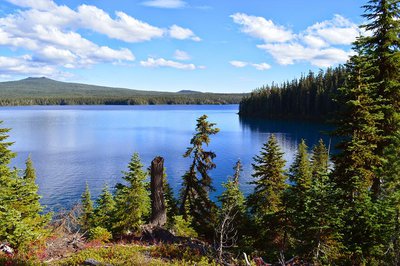
To continue towards Waldo Lake, veer left away from the falls onto a decidedly drier slope. The trail continues uphill, steeply at times until you reach Waldo Lake. After a couple of switchbacks the forest changes dramatically to one dominated by mountain hemlock and true fir with bear grass and huckleberry making up the understory. On some of the rocky slopes that look out over the deep canyon that Black Creek has cut you will find Douglas maple, which add some lovely fall color to the hike.
If you’re interested in a nearly 8-mile hike, then head south on the Waldo Lake trail approximately half a mile to Klovhdal Bay. Throughout much of the early 1900s different corporations attempted to divert the water of Waldo Lake down the Black Creek Canyon in order to produce electricity and water for irrigation in the Willamette Valley. Klovhdal Bay is named for Simon Klovhdal, who designed a tunnel system to lower the level of Waldo Lake 25 feet. Thankfully, this and subsequent projects to exploit Waldo Lake failed.
Huckleberry along the shores of the incredibly clear Waldo Lake provides a little bit of fall color. At this point, return the way that you came. Many trails along the western side of Waldo Lake could be combined with the Black Creek Trail for extended backpacking. If you’re heading out for this hike soon be prepared for cold, rain and possible snow. Also worth hiking in the area is the Joe Goddard Interpretive Trail, which is approximately half a mile. Absolutely massive Douglas fir and Pacific yew can be found there. To reach the Joe Goddard Trail, simply turn off to the right 1.5 miles before the end of Forest Road 24.
Directions from Eugene:
Follow Hwy. 58 for 40 miles to Oakridge, turn left at the only stop light, turn right onto 1st Street, which becomes FR 24 (Salmon Creek Road). Follow for 21.5 miles to the end of the road.
Hike Distance: 7.5 miles
Hike Type: Out and Back
Elevation Gain: 2,000 feet
Trailhead Elevation: 3,400 feet
Usage: Light
Difficulty: 2 out of 5
Fees: None