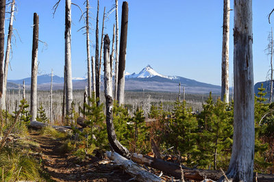
Despite the potentially disastrous effects a multiyear, recording-breaking drought will have on the people and wildlife of western Oregon, there is a small consolation prize: early season hiking near the Cascade Crest.
Typically trails in the Mount Jefferson Wilderness are under snow through late June, but with snowpack in the Willamette Basin at an abysmal 8 percent of the normal snowpack for that area, the majority of snow below 6,000 feet has already melted.
Situated 2 miles west of Three Fingered Jack is 15-acre Santiam Lake. There are two primary ways that Santiam Lake can be reached: from the west via the Duffy Lake Trail or from the south via the Pacific Crest Trail (PCT) near Santiam Pass.
I suggest hiking via the PCT because of the unique post-fire forest. This area burned in the 2003 B&B Complex fire. Lodgepole pine and beargrass are the primary plants repopulating the area. Post-fire early seral forest is very rare because it is often salvage-logged. Thankfully, this area was spared because it’s within a wilderness boundary.
After gently ascending for nearly 1 mile you will come to the Santiam Lake Trail junction. As you begin to walk west, Mount Washington and South Sister can be spotted through the fire-killed trees. Three small lakes that make for a decent camp are just off trail to the west after you begin to walk north again. You will continue northwest while weaving in and out of areas that were spared from the B&B fire. These patches of forest that were not burned provide welcome refuge from sun.
Subalpine fir, mountain hemlock and western white pine are all found within these unburned patches. Near the 3.5 mile mark, you will ascend a few hundred feet towards a small pass just south of Upper and Lower Berley Lakes. These lakes can be accessed by following an outlet stream west from the Santiam Lake Trail.
If you walk past a van-sized boulder, you’ve gone too far. You will then pass through two nearly flat sandy areas before ascending into a dense mountain hemlock dominated forest. Mount Jefferson quickly comes into view along with stunning views of Three Fingered Jack in the meadow above Santiam Lake.
There is a small grassy area just east of where the trail reaches the southern shores providing a beautiful area for lunch. If you’re planning to camp in the area, be sure to set up at least 200 feet from the shore of Santiam Lake. Return the way you came.
Directions from Eugene: Follow Hwy. 126 east for 68 miles, merge right onto Hwy. 20, follow for 8.8 miles; trailhead is a well-marked left turn.
Hike Distance: 11.5 miles round trip
Hike Type: Out and back
Elevation Gain: 700 feet
Trailhead Elevation: 4,800 feet
Usage: Moderate
Difficulty: 2 out of 5
Fees: $5 or a Northwest Forest Pass