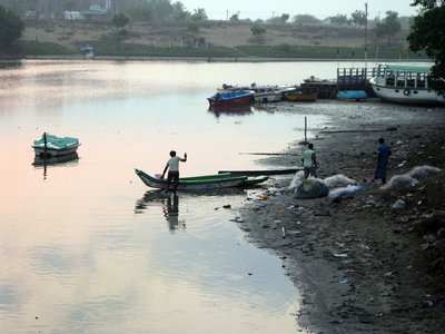
An “ultra mega” coal-fired power plant is proposed for the coastal state of Tamil Nadu in India, on the shores of the Cheyyur Lagoon. The plant would churn out 4,000 megawatts of power and 25 million tons of carbon dioxide per year, according to the Environmental Law Alliance Worldwide (ELAW), which is aiding communities in India in their fight against the plant and 11 other ultra mega coal proposals.
In addition to legal and scientific advice, ELAW is also helping “ground truth” this and other environmentally devastating proposals across the world, not only with boots on the ground, but also with the technology of Google Earth from afar.
Sitting in front of his computer at ELAW’s offices in Eugene, staff scientist Mark Chernaik uses Google Earth to swoop in on proposed hydropower projects in Veracruz, Mexico; a hazardous waste facility in Gujarat, India; a levy in Jamaica and myriad other ecologically problematic proposals all over the world.
Chernaik, fellow staff scientist Heidi W. Weiskel and environmental research scientist Graciela Mercedes Lu all have stories of environmental impact assessments (EIAs) that attempt to gloss over just how much damage a project might do. Ground truth in the environmental sense is using data and observations from the field to prove or disprove claims about a project.
“We do this fairly regularly,” Chernaik says of using Google Earth to prove projects will have a much greater environmental impact than their developers say they will. In a typical case, Lu says, a developer will claim a mine proposal or a development is in “degraded” forest, and then ELAW uses Google Earth’s detailed images to reveal that in fact the land is not degraded at all.
Google Earth is free for groups like ELAW to use, though in some instances Google requires users to buy Google Earth Pro, and it demands that users give it attribution for its products, that users not change the maps and they not be used for items for resale.
At Cheyyur Lagoon, the community members are not only facing a massive coal burning plant, but also its dirty coal emissions as well as a coal yard with a massive pile of coal, a railroad, truck road, a conveyor for coal and a toxic coal ash pond.
Weiskel has gone to Tamil Nadu and met the people who live near the lagoon, talked with the ELAW partners working there and seen the birds, fish and wildlife that will be affected if the ultra mega plant goes through. “I’m always struck by the beauty of the place,” she says.
In addition to the photos taken on the ground, ELAW uses Google Earth to litigate projects such as the power plant by comparing the EIA’s geographic coordinates and images with Google Earth.
Weiskel says the EIA was incomplete and inaccurate and shows the massive coal conveyor as traveling over nothing, when in fact there will be “substantive impacts” to the community.
Chernaik pulls up another proposed development in India on his computer screen, this one a proposal for a private airport in the wetlands near Aranmula in Kerala, India. Community groups represented by ELAW partner T. Mohan fought the airport and ELAW assisted in the battle. Local residents were disturbed by the airport’s proximity to a Hindu temple and by the proposed conversion of rice paddy fields to make way for the project, threatening wetlands and fisheries in the Pamba River basin.
Chernaik says the impact assessment offered an image of what the airport would look like. He was skeptical — the image indicated the runway would be quite small, too small for planes to actually take off and land. So he pulled it up in Google Earth and discovered that “No matter where you put the runway, it would intersect with forested wetland areas.”
India’s National Green Tribunal agreed that the impact assessment was deeply flawed and canceled the clearance for the airport early in the summer of 2014. The judgment cited the “pristine ecosystem” of the area, that the public hearing about the airport “was conducted in a clandestine and undemocratic manner,” that the impact assessment said the area had “22 species of plants and a few grasses as the flora in the region,” when in fact there were 212 species of plants alone and, as Chernaik found using Google Earth, there was no way the 2,300-meter runway as depicted in the document was going to fit in the space the developer said it would.
ELAW and its partners also use archival images in Google Earth to show impacts over time. Year by year, with clicks of the mouse, Chernaik can show how sediment builds up behind the levy in Jamaica and damages the fragile ocean ecosystem around it.
Lu points out that as ubiquitous as technology like Google Earth is, not everyone has access to high-speed internet and a computer that can run the program, but when ELAW helps its partners by sending a report that includes images, “the authorities can’t say you are wrong.”