The Corvallis skyline is a dreamland — not of skyscrapers, but of forested peaks. A hike to Fitton Green takes you to a viewpoint that fulfills a dream to preserve a “greenbelt” around the city’s hills. A snowshoe trip to Marys Peak takes you to an earlier vision site — the “spirit mountain” of Kalapuya legend.
Start with the easy 1.4-mile loop hike to Fitton Green. The park’s name honors Elsie Fitton Ross, who together with her husband Charles Ross endowed a Benton County trust fund in 1988 with the goal of preserving a rim of parkland in the hills around Corvallis and Philomath. The trust’s initial purchase of 85 acres here has since grown to a string of parks toward that goal.
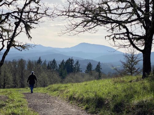
The view from Fitton Green’s meadowed slope sweeps from the Three Sisters to Marys Peak and Eugene’s Spencer Butte.
The shortest route to the viewpoint begins at a trailhead with room for only 10 cars, so parking can be tight. To get there from the junction of Highways 20 and 99W in Corvallis, take Hwy 20 toward the Oregon Coast for 2.5 miles, turn right on SW 53rd Street for 1.4 miles, turn left on Oak Creek Drive for 1.8 miles, veer left on Cardwell Hill Drive for 0.7 miles, turn left on Chinook Drive 0.5 miles, turn right on Chaparral Drive 0.5 miles, and fork to the right on Panorama Drive for 0.6 miles to its end.
From this upper trailhead, walk past a locked gate on a wide gravel path for 0.2 miles to a fork at the start of the one-mile Throop Loop. Go uphill to the left. The path crosses a spectacular meadow to a viewpoint bench and switchbacks down a grassy ridge. Keep right at the junctions to return to your car.
Was that too easy? Or was the upper parking lot full? Then start at the Oak Creek Trailhead instead and hike up Mulkey Ridge to Fitton Green. You passed this trailhead parking area on your way, 0.8 miles up Oak Creek Drive. From the lower trailhead it’s 4.3 miles to Fitton Green, gaining 1,900 feet of elevation. The route through the oaks is so lovely it’s worth the effort.
Fitton Green is wonderful, but the area’s best view is atop Marys Peak. At the highest point in the Coast Range, your panorama stretches from the Cascades to the Pacific. As you hike to the summit you can contemplate the peak’s legends.
The Kalapuya tribe that once dominated the Willamette Valley was decimated by diseases brought by European explorers. Smallpox, measles, influenza and diphtheria swept through Native villages, killing as many as nine out of 10. By 1910, only eight members of the Luckiamute band of Kalapuyans survived.
As a result, large parts of the Kalapuyan legends have been lost. The fragments that remain reveal that the Kalapuyans, like most Northwest tribes, set their tales in an age when animal spirits walked the earth. Coyote, a schemer whose plans often went awry, was the most powerful of these legendary demigods. Marys Peak was known to the tribe as Chateemanwi, “the place where spirits dwell.”
According to the legend, a monster roamed the Willamette Valley, devouring animals. Coyote defeated it by flooding the valley and retreating to Marys Peak.
Geologists report that the Willamette Valley was in fact filled 300 feet deep by a series of Ice Age floods. The floods were triggered when the continental glacier in Canada advanced across a branch of the Columbia River in northern Idaho, damming a lake into the Rocky Mountains. Each time the ice dam burst, a gigantic flood churned through the Columbia Gorge and puddled up in the Willamette Valley.
Could the Kalapuyan tale be a memory of those glacial floods? Arguing in favor of that theory is the Kalapuyan name for Marys Peak itself. “Chateemanwi” includes a form of the word for spiritual power, preserved in Chinook Jargon as tamanawas. The Kalapuyans revered three spiritual mountains — Marys Peak, Mt. Angel north of Salem, and a hill on the Grande Ronde reservation near the present-day Spirit Mountain Casino. Those three summits would have been refuges during the apocalyptic Ice Age floods.
To see Marys Peak for yourself, drive Hwy 20 west of Corvallis through Philomath, fork left onto Hwy 34 for 8.8 miles and turn right on paved Marys Peak Road 9.5 miles to its end. From there, you can hike — or snowshoe — a gated service road for 0.6 miles to the summit. With this season’s late spring snows, I’d recommend bringing snowshoes.
The viewpoints on the skyline of Corvallis still draw those who seek quiet contemplation and far-ranging views. They’re also a good safe place in a flood.
William L. Sulllivan is the author of 23 books, including The Ship in the Woods and the updated 100 Hikes series for Oregon. Learn more at OregonHiking.com.
